
Hurricane Sally makes landfall in Alabama as a Category 2 storm batters the US
Hurricane Sally barreled into the Gulf Coast Wednesday morning, making landfall as a Category 2 near Gulf Shores, Alabama.
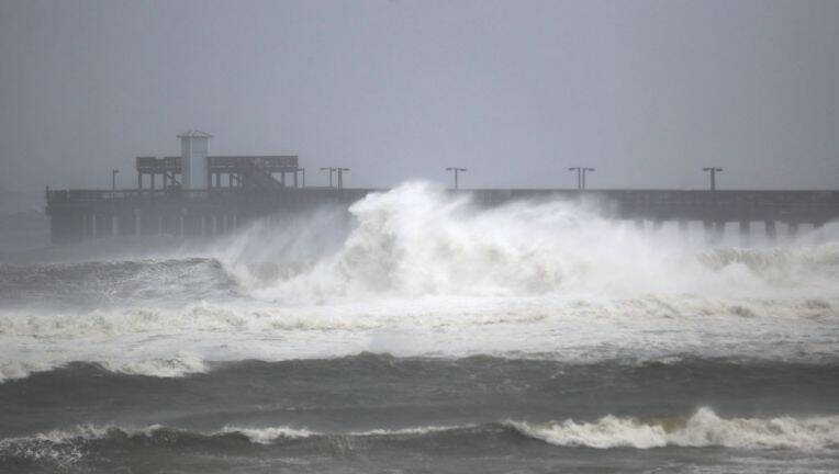
Sally struck around 5:45 a.m. ET with winds of 105 mph.
The storm was moving slowly in the Gulf overnight Tuesday and churning into a Category 2 hurricane, and conditions deteriorated overnight. The Pensacola Police Department in Florida urged people to stay off the roads because hazardous debris "have become too numerous to list," and the National Weather Service office in Moblie, Alabama, warned people to "hunker down."
The office reported 70 mph wind gusts in West Mobile and also issued a flash flood emergency, saying these "warnings are issued for exceedingly rare situations when a severe threat to human life & catastrophic damage from a flash flood is happening."
"This is a LIFE-THREATENING SITUATION. SEEK HIGHER GROUND NOW!!," the NWS Mobile office tweeted.
More than 320,000 customers are already without power along the Gulf Coast and thousands have evacuated ahead of the storm.
The storm has brought flooding and storm surge to several coastal communities and prompted the evacuation of thousands of people directly in its path.
The storm's slow speed is expected to continue through Wednesday as it turns to the north and then northeast, bringing with it strong winds and potentially historic flooding.
Satellite imagery of Sally indicates the eye reforming early Wednesday, which is another sign of strengthening, CNN Meteorologist Michael Guy said.
Rainfall of 10 to 20 inches is expected across Mississippi, Alabama and the Florida Panhandle, with isolated amounts of 30 inches possible.
The slow moving nature of the storm also means that hurricane force winds and storm surge will be in the area longer, particularly to the east of the storm center.
Flash flooding with rainfall amounts of 6 to 10 inches could be seen in Georgia and the Carolinas later this week as the storm moves inland and weakens.
Widespread power outages and water repairs delayed
More than 150,000 customers have lost power in Alabama, Mississippi and Florida as of early Wednesday morning, according to PowerOutage.US.
Those in the path of Sally are also experiencing water outages as conditions are unsafe to make repairs to utilities because of the storm.
Authority issued an alert Tuesday that they are unable to respond to a significant water main break in Pensacola Beach due to storm conditions and bridge closures ahead of Sally.
The water system had to be shut off at approximately 11:00 p.m. as storm surge and tide levels will also inundate the sewer collection system, according to ECUA.
"We urge residents who are still on Pensacola Beach to store water if possible. ECUA will dispatch crews to locate the break and make repairs as soon as possible post-storm," the notice said.
Sally struck around 5:45 a.m. ET with winds of 105 mph.
The storm was moving slowly in the Gulf overnight Tuesday and churning into a Category 2 hurricane, and conditions deteriorated overnight. The Pensacola Police Department in Florida urged people to stay off the roads because hazardous debris "have become too numerous to list," and the National Weather Service office in Moblie, Alabama, warned people to "hunker down."
The office reported 70 mph wind gusts in West Mobile and also issued a flash flood emergency, saying these "warnings are issued for exceedingly rare situations when a severe threat to human life & catastrophic damage from a flash flood is happening."
"This is a LIFE-THREATENING SITUATION. SEEK HIGHER GROUND NOW!!," the NWS Mobile office tweeted.
More than 320,000 customers are already without power along the Gulf Coast and thousands have evacuated ahead of the storm.
The storm has brought flooding and storm surge to several coastal communities and prompted the evacuation of thousands of people directly in its path.
The storm's slow speed is expected to continue through Wednesday as it turns to the north and then northeast, bringing with it strong winds and potentially historic flooding.
Satellite imagery of Sally indicates the eye reforming early Wednesday, which is another sign of strengthening, CNN Meteorologist Michael Guy said.
Rainfall of 10 to 20 inches is expected across Mississippi, Alabama and the Florida Panhandle, with isolated amounts of 30 inches possible.
Sally's two biggest threats are inland flooding and storm surge
Florida's National Guard has activated 175 members to prepare for search and rescue operations, with 30 foot high water vehicles on standby for use if needed, according to a tweet from the Division of Emergency Management. And police in Pensacola have warned residents to stay off the roads as "flooded roadways" and "hazardous debris ... have become too numerous to list."The slow moving nature of the storm also means that hurricane force winds and storm surge will be in the area longer, particularly to the east of the storm center.
Flash flooding with rainfall amounts of 6 to 10 inches could be seen in Georgia and the Carolinas later this week as the storm moves inland and weakens.
Widespread power outages and water repairs delayed
More than 150,000 customers have lost power in Alabama, Mississippi and Florida as of early Wednesday morning, according to PowerOutage.US.
Those in the path of Sally are also experiencing water outages as conditions are unsafe to make repairs to utilities because of the storm.
Authority issued an alert Tuesday that they are unable to respond to a significant water main break in Pensacola Beach due to storm conditions and bridge closures ahead of Sally.
The water system had to be shut off at approximately 11:00 p.m. as storm surge and tide levels will also inundate the sewer collection system, according to ECUA.
"We urge residents who are still on Pensacola Beach to store water if possible. ECUA will dispatch crews to locate the break and make repairs as soon as possible post-storm," the notice said.


Post a Comment